
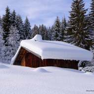
The Avenaz Chalets - Snowshoe Trail
Medium
3h05min
6.1km
Round trip
+371m
-369m


1 / 9
Description
A beautiful hike through the heart of the Jorasse Forest—which is traditionally covered in deep snow—to reach the highest point, Avenaz, and its chalets. There’s a lovely view of the mountains waiting for you at the summit!
Following the forest road there and back, this challenging hike will take you through the forest at first, then offer a beautiful, unobstructed view of the Mont Blanc range and the Aiguilles de Warens once you reach the summit.
Difficult sections
Slightly steeper path back to the heights, for experienced walkers
Marking
The trail for the Avenaz loop is marked with fuchsia-colored signs.
Map references
Map of snowshoe trails
IGN Top 25 map or map of viewpoints from the tourist offices


